A Smarter Way to Manage Borehole Data in Modern Mining
Written by: Esther van der Vyver Save to Instapaper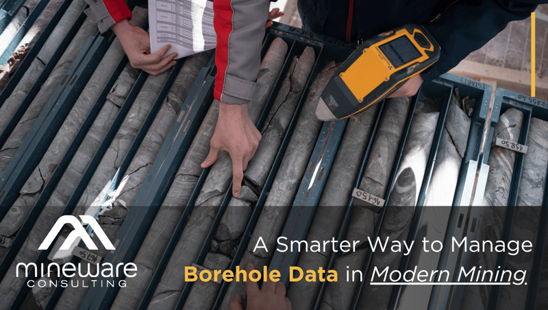
Accurate geological information forms the foundation of safe and efficient mining operations. Yet the process of capturing and managing borehole data has often been fragmented, relying on manual notes, disconnected tools and inconsistent field conditions.
Boreholes are drilled both during exploration and as part of day to day mining activities. These holes may be relatively short, sometimes only a metre in length, or extend for kilometres depending on the purpose of the drilling programme. Regardless of scale, they provide essential insight into the underground environment.
Through boreholes, geologists gather critical information about mineralisation, underground geological structures and faulting, as well as the presence of water or gases such as methane. This information plays a vital role in resource understanding, mine planning and operational safety.
To be useful, however, this data must be captured accurately and stored in a structured way that allows it to be analysed and visualised. When borehole information is fragmented across notebooks, spreadsheets or isolated devices, it becomes difficult to maintain data integrity or use the information effectively.
Mineware’s Geology Boreholes system introduces a more resilient and integrated approach to managing this critical geological data.
Built for the Realities of Field Work
Drilling often takes place in remote environments where network connectivity cannot be guaranteed. Field teams therefore need tools that continue to function reliably even when they are completely offline.
The Geology Boreholes system is a web-based capture platform that allows users to record borehole logs, lithology and field observations directly at the drill site. The system operates fully offline when required, ensuring that geological data can still be captured in areas with no signal.
Because the platform is web based, it can run on smaller and more cost-effective devices while still delivering the same functionality and results. This makes it practical for teams working in challenging field environments.
Once connectivity is available again, the captured data synchronises automatically with the central database. This ensures that information collected in the field becomes immediately available to the wider geological and planning teams.
From Field Data to Geological Insight
Once stored in the central database, borehole information becomes far easier to manage, analyse and visualise. Structured data can be used to support plotting, geological interpretation and modelling of the ore body and surrounding structures.
The system also integrates directly with widely used CAD platforms, allowing borehole data captured in the field to be converted into accurate technical drawings and geological representations more efficiently.
This streamlined process significantly reduces the time required to move from field observations to usable design inputs.
Strengthening Data Integrity Across the Workflow
In modern mining environments, the reliability of geological data is critical. Decisions relating to planning, safety and production all depend on accurate information.
To support this, the Boreholes system connects natively with Mineware’s LIMS and QAQC modules. This integration ensures that sample management and quality control processes remain aligned with the geological data captured in the field.
From the moment a sample is logged at the drill site through to laboratory analysis and reporting, the workflow remains connected and traceable.
Efficiency from Drill Rig to Design
By combining offline field capture, structured database storage, CAD integration and quality assurance workflows, the Geology Boreholes system creates a seamless digital process for managing borehole information.
Field teams can capture data reliably wherever drilling takes place. Technical teams gain immediate access to structured geological records. Engineering teams can transform field data into design outputs far more quickly.
The result is a more connected geological workflow that saves time, reduces manual processing and ultimately lowers operational costs.
From exploratory drilling to day to day operational boreholes, the ability to capture, store and design from reliable geological data anywhere represents a significant step forward in modern mine data management.
Contact the Mineware team for a demo.
Get new press articles by email
Founded over twenty five years ago in South Africa, Mineware Consulting consists of a team of talented developers and designers specializing in creating operational mine management software for the mining industry. Mineware crafts bespoke management solutions that marry a deep pool of mining expertise with forward thinking software packages, using data to solve mining problems. Our... Read More
Latest from
- Digital Innovation in Mine Surveying - Flexible Resection Capability for Modern Mining Operations
- Mineware Consulting to Join Datamine Group
- Why Digital Mine Management Is No Longer Optional
- Mineware introduces AI-first OCR to accelerate mine safety intelligence
- How Danko makes showing gratitude the easiest part of your day
- The Truth About Olive Oil Labels - How to Recognise Real Extra Virgin Olive Oil
- How to Choose the Right Olive Oil for Cooking, Dressing, and Dipping
- Petra Diamonds Begins Implementation of Mineware’s Safety and Risk Management Software Suite
- Mineware Consulting - The Role of Big Data and Analytics in Modern Mining
- Analysing The New Language of Customer Loyalty
- From Burnout to Balance - How Auraliti AI Transforms Mental Health Practice Management
- AI and POPIA Compliance - What Every Healthcare Professional Needs to Know
- Same Shift, More Tonnes - Short-Interval Control for South African Open Pits
- The New Practice Standard - Why Clinicians Must Embrace Compliant AI (And How to Avoid the Risks)
- Integrating Safety and Production Data - The Future of Mine Risk Management
The Pulse Latest Articles
- Magic: The Gathering Assembles The Marvel Super Heroes (June 17, 2026)
- Rethinking Performance: Part 4 Of 5 Why Judgement Matters In Performance Evaluation (June 15, 2026)
- How Should Water Feel? Inside The Innovation Shaping Modern Showering (June 15, 2026)
- Hisense Launches Soweto Football Pitch Project (June 12, 2026)
- Magic: The Gathering Assembles The Marvel Super Heroes (June 12, 2026)