Helping farmers one tree at a time - Revolutionary Aeroview Scout smartphone app to help farmers in today's challenging climate
Submitted by: Dylan
Revolutionary Aeroview Scout in-field app launched by Aerobotics helps highlight problem areas in the orchard, helping farmers save costs and water.
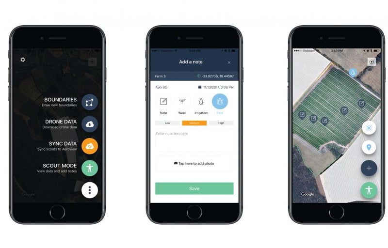
Cape Town, 6 December 2017 – Leading South African technology company, Aerobotics, which specialises in providing on-demand satellite and drone analytics for farmers, today officially launched the revolutionary Aeroview Scout in-field smartphone app that highlights problem areas in the orchard with GPS co-ordinates, allowing farmers to make notes, take pictures and remedy any issues early. Aeroview, developed by Aerobotics, uses artificial intelligence (AI) and a unique set of algorithms to transform satellite and drone imagery into useful information to assist farmers and help them optimise profits and yield by identifying problem areas in the orchard. Using visual and multispectral camera, the drones map the outlined area in 3D, highlighting individual trees with health or growth problems, and can even detect leaks – all leading to cost savings for farmers in the long run.
Farmers can look at each individual tree’s statistics, including health, height, canopy size and canopy volume. Crop health maps highlights problem areas on the farm and moisture index maps reveals any leaks to help reduce water usage and facilitate more effective irrigation. Aeroview Scout, the in-field smartphone app launched today, complements the Aeroview platform with GPS co-ordinates for individual trees so farmers can locate trees with issues, make notes, take pictures and remedy the problems early. The app also tracks progress of each affected tree (including in-field notes) so farmers can better manage their time and resources on a regular basis, reducing wastage in irrigation and pest management and helping farms to be more sustainable in their use of herbicides and pesticides.
First Fruits Consulting, a well-regarded citrus farm consultancy based in Simondium in the Cape Winelands, has been using Aeroview to help citrus farmers across the country improve their yields. “Since we started using Aeroview in 2016, the data has helped farmers find problem areas in their orchards and correct these areas through differential application of ameliorants and other area specific inputs, thereby increasing overall productivity in the orchards. In some cases, improvements could be seen clearly using drone data within only a couply of weeks after amelioration. With the Aeroview Scout in-field smartphone app, farmers can better react to problem areas in orchards, find the affected trees easily and remedy the issues quickly,” said Hein Gerber, Managing Director, First Fruits Consulting (Pty) Ltd. For farmers growing fruits for the lucrative export market, being able to spot problems in trees early can help reduce crop failure and lost income. In a study conducted by Aerobotics on a 3.75 hectare Western Cape peach orchard, the Aeroview data highlighted how the farm could generate more exportable fruit by addressing the trees in need of help – the data would have mitigated a R400,000 loss in income for the farm.
The on-demand satellite and drone scans are not only limited to trees in an orchard. In 2016, the South African Cane Growers’ Association (CANEGROWERS) formed a partnership with Aerobotics to provide data for sugarcane farmers so they can reduce costs while increasing yields, improve sustainability and maximise profitability in today’s tough economic times. “Aeroview is becoming a key tool for us and our growers. The analysed data allows us to identify crop stress and address threats early, before the damage become widespread. Improving crop yields starts with the measurement and monitoring capability provided by Aeroview, which provides a key technological tool for improving farming practices and yields,” said Richard Howes, Head of Innovations at CANEGROWERS. James Paterson, Chief Executive Officer, Aerobotics, agrees: “Aeroview Scout is precision farming in the palm of your hands.
This smartphone app is going to be the next essential tool for all farmers who aim for greater yields and profits, while saving water at the same time.” Since its launch in 2014, Aeroview today has users in South Africa, Australia, New Zealand, Malawi, Zimbabwe, Mozambique and the UK. Aeroview Scout is available on both the Apple and Android App Store. For more information on Aeroview and Aeroview Scout app, please visit aerobotics.co.- End -For high resolution screenshots of the Aeroview Scout app, please visit: https://drive.google.com/open?id=0BxVcu9bF02QSRjlqU1pmanFFY2c
About Aerobotics
Established in Cape Town in 2014, Aerobotics is a leading South African company providing on-demand satellite and drone analytics for farmers to help them farm better. It is the developer of Aeroview, which uses artificial intelligence (AI) and a unique set of algorithms to transform satellite and drone imagery into useful data to identify problem areas on the farm with crop health maps, moisture index maps and individual tree statistics, including health, height, canopy size and canopy volume. Using the Aeroview Scout in-field smartphone app, farmers can locate each problematic tree using GPS co-ordinates, make notes, take pictures and track progress of treatment for each tree over time.
For more information about Aerobotics and Aeroview Scout, please visit aerobotics.co
For media enquiries, please contact:
Rachel Stevenson
E: This email address is being protected from spambots. You need JavaScript enabled to view it.
T: (073) 977 6131
Dylan James
E: This email address is being protected from spambots. You need JavaScript enabled to view it.
T: (066) 206 2109

